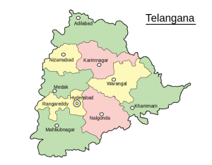
Climate of Telangana
Introduction to Telangana:
In 2014 Telangana became the 29th state of India. There was a lot of turmoil in the state of Andhra Pradesh for a very long time, and it was led by K ChandrashekharRao, who wanted a separate statehood for Telangana since 2001. It took nearly 50 years for Telangana to get freedom and the struggle was referred to as the Telangana Movement. This marked both as a beginning as well an end. It is the end of a prolonged struggle which lasted over six decades and it was also the beginning of a process of creating a new identity for them.
Geography of Telangana:
Telangana has an area of 1,14,800 square kilometres and it is drained by two major rivers, Krishna and Godavari. The river Godavari flows on the north, whereas Krishna flows in the south. Apart from these rivers, there are other small rivers such as Bhima, Dindi, Manjeera, Manair, Kinnerasani, Moosietc, which also flow through Telangana. 45% of the forest area of Andhra Pradesh is in the state of Telangana. It also has a vast coal deposit and around 20% of India’s coal deposit lies in Telangana. The coal produced from this region is supplied to the states in south India.
Climate of Telangana and Temperature
Telangana is a semi-arid zone and has a predominantly hot and dry climate. The areas covered by the Deccan Plateau are characterized by hot summers with relatively mild winters. In Telangana region, the mean maximum temperature varies between 40 C and 43 C in May and the mean minimum temperature is 13C to 17C in December and January. The minimum temperature falls rapidly after October, and less than 10C has also been recorded on certain days.
Rainfall
The State receives rainfall from South-West (June – September) and North –East
(October–November) monsoons; however, there is large variation in thedistribution of rainfall. Telanganagenerally receives modest rainfall. The average annual rainfall in the state is about 906 mm, 80 percent of which is received from the South-West monsoon (June-September).
Humidity
In Telangana, humidity is as high as 80% during monsoon months (July-September). In the dry months of March, April and May, humidity is generally low with an average of 25 to 30%.
Heavy Rains
Due to low pressure system which developed in West Central Bayof Bengal and adjoining areas there were torrential and incessant rains in the districts of Mahabubnagar and Nalgonda in the year 2009,2012 and 2013.
Floods
Floods by nature depend on several factors; one being incessant rains;rains in a short period of time crippling natural drainage. However, other factors such as nature of the collecting basin, nature of the streams, type of soil, natural and man-madevegetation, amount of rainfall, obstruction to natural drainage etc. determine the type and extent of floods.Khammam district in Telangana region is most prone to monsoon floods.
Droughts
The Central Water Commission defines drought as a situation occurring when the annual rainfall is less than 75% of the normal (defined over 30 years average). Drought is a normal, recurrent feature of Climate of Telangana. It occurs in virtually all climatic zones, but its characteristics vary significantly from one region to another. The table 7 &8 shows district wise total no. of mandals affected from droughts in year 1995-
96 to 2011-12. It shows that Telanganahas historically been prone to drought conditions especially in Rangareddy, Mahabubnagar and Nalgonda districts. Climate is projected to increase drought occurrence in the districts like Nalgonda and Mahabubnagarwhich would impact not only water resources but also have a cascading effect on other dependent sectors. Increased drought conditions can also severely affect agricultural andpastoral livelihoods and increase vulnerability and risks for farmers, and peopledepending on such livelihoods. For farmers who are strongly dependent on rainfall foragricultural activities, crop failure caused by drought can lead to household food insecurity. For pastoralists and agro – pastoralists whose livelihoods and food security depend on livestock, drought conditions can cause malnutrition or disease in livestock because of insufficient fodder.
Heat Waves of Climate of Telangana
A heat wave is a climatologically extreme event involving abnormally higher temperature relative to normal15during the Summer i.e. the months of AprilJune.During this period the temperatures rise considerably, sometimes touching 47ºC in Maymonthin districts like Khammam, Nizamabad, Nalgonda, Karimnagar and Warangal. During the year 1986-1993, the heat waves were mainly of moderate nature with maximum duration of seven days. The highest maximum temperature of 47C was recorded at Nalgondaand Ramagundam on 11thMay,1998.From 1994 onwards, the frequency of severe heat waves and the duration of heat wave spells have increased significantly. In 1997 (18th
May to 5thJune) and 1998 (23rdMay to 10thJune).
State Action Plan on Climate Change for Telangana State32Environment Protection Training & Research Institutethe duration of moderate to severe heat wave spells had extended up to 19days.Since Heat wave conditions prevail in several parts of the state during summer season, deaths due to sunstroke occur every year. Inspite ofvarious measures taken by Government,541 deaths
due to sunstroke had beenreported in the year 2015(as on30thMay, 2015). The maximum deaths were recorded inNalgonda, Khammam, Karimnagar and Mahabubnagar districts, where the temperatures have crossed 45° C.
EFFECTS OF CLIMATE CHANGE ON Climate of Telangana
Issues-
- Higher vulnerability of the State towards climate change.
- The river basins are prone to climate change impacts due to changing precipitation and temperature patterns.
- Industrial hubs are prone to climate change impacts due to unscientific construction and water and electricity scarcity.
- Majority of rural and urban population is not aware about the climate change issues and impacts
- Lack of Climate Change knowledge center in the State